
Desolation Sound is a stunning environmental reserve at the northern tip of the Sunshine Coast in British Columbia. In May 2015 I explored parts of the Sound on a four-day kayaking trip. It requires a fair amount of time and effort to get to Desolation Sound, which ensures a modicum of quiet and reprieve from the Lower Mainland crowds. Yet the area is just close enough to Vancouver to be a fantastic destination for an extended long weekend.

Our group of five left on Thursday after work, slowly escaping the city traffic and boarding the ferry from Horseshoe Bay to Langley. It was a good thing we booked in advance, as the ferry was packed with carloads of like-minded people getting away for the long weekend.
From Langley we drove north through the industrial centre of Powell River to Earl’s Cove, just making it in time for the next ferry to Saltery Bay. This ferry is a lot smaller and it seemed we had travelled far enough away from Vancouver for the crowds to have thinned. After disembarking and another hour of driving we found ourselves in Lund- the northernmost town of the Sunshine Coast. By this time everyone was exhausted. Finding the campsite in the dark at SunLund-by-the-Sea RV Park was an interesting task for already weary travellers, and it was with relief that we finally climbed into our sleeping bags around 12:00 am.
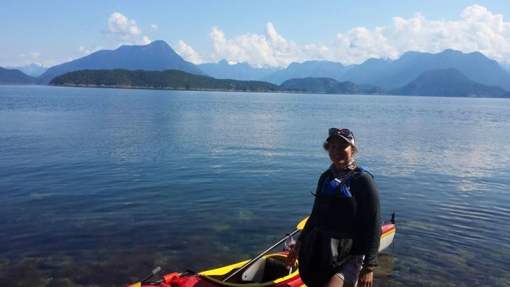
Although we wanted to sleep in, we were on the road early to get a good start on the day’s paddling. Kayaks were rented from Powell River Sea Kayaks and cost about $240 for a double kayak for four days. This is where our preparation skills were put to the test. We’d pondered over what gear to bring, how much food, and how much water. Over the previous week I’d added things in to my gear pile on the lounge room floor, only to reconsider and take things away again. Now, faced with the seemingly small cavities of the double kayak, I could see that it was going to be a struggle to fit everything inside. Of course, the rising tide did not help the already stressful situation. Here’s a handy tip: if the tide is coming in do not place the kayaks right next to the water’s edge for packing. You’ll end up with wet gear and suddenly buoyant kayaks taking off without you.
Packing issues finally resolved, we set off. Once moving, we settled into a good rhythm, steadily making our way up the Okeover Arm. Houses slid by on the left and right and became increasingly more dispersed until the banks became pure green forest.
For lunch, we stopped at the Hare Point campsite. There is a nice little pull-in where you can tie up the kayaks and climb the banks to a table and chairs perched on the edge of the rocks. It was here that I started to notice the incredible shore biodiversity. Giant sea anemones and sea urchins sat just below the surface, alongside large orange and purple sea stars.

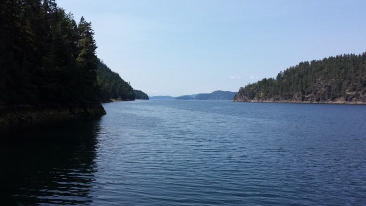
I would recommend timing this part of the paddling with the outgoing tide. Okeover Inlet turns into Malaspina Inlet, which narrows towards the entrance and currents can be quite strong and tedious to paddle against.
Although we paddled against the current to get to the end of the Inlet, once we rounded the corner into the main sound, the tide was with us as we headed across the open water to the eastern side of Mink Island. From here we hugged the coastline until reaching our camping destination for the next three nights: the Curme Islands.
After checking out all three of the Curme Islands, we decided on the eastern-most island for our camp. There are toilets and tent pads, but not much else on these islands. You need to bring all of your drinking water with you, as there is none available on the islands. Note that a backcountry camping permit is also required: you can obtain this online.

The next day we set off to Black Lake, a delightfully warm fresh water lake in the Roscoe Bay Marine Park on West Redonda Island. There is a small cove where kayaks can be pulled ashore, and picnic tables on a grassy slope under the trees. The lake is a short walk away. We all went for a swim in the inviting, clear water and dried out on the rocks in the sun.

On Sunday we ventured north-east across the sound to Prideux Haven, which is a popular anchoring point for yachts and other pleasure craft. Here we stopped for lunch and a swim after finding a rocky outcrop with deep water below- perfect for jumping off into the cool, salty water. One thing that we found challenging on the trip was finding suitable spots to pull the kayaks into when we wished to get out. There are no sandy beaches in Desolation Sound; rocky shorelines covered in sharp barnacles are the norm. Conscious of not damaging our rental kayaks, finding places to pull in where we weren’t scraping the fibreglass hull over rocks and barnacles was difficult. I would recommend bringing some sturdy footwear with a good sole to wear in the kayak, as a friend that wore flip-flops ended up with cuts all over her feet. On a similar note, the tidal changes in this part of the world are large, so you must pull the kayak quite far up from the water’s edge and secure it with rope to a tree or rock, lest you wake up in the morning to see your vessel floating away.
Around mid-afternoon we started to make our way back towards camp, spotting a large sea lion on the rocks and so many starfish we lost count along the way. We poked our heads into Tenedos Bay – a sheltered bay with campsites and pit toilets. There is a short 10-minute hike here to Unwin Lake, which we opted not to do on this trip.

That evening, we made a feast at the campsite, swam in the sheltered bay, and foraged for oysters on the shoreline as dusk arrived. I love oysters so was very tempted to try one, but thought I had better not. If they ended up making everyone sick there needed to be one person well enough to call for help!

Monday arrived and it was time to pack down the campsite and turn the kayaks for home. Retracing our path from Friday, we paddled as quickly as we could back to Okeover Arm before starting the long journey back to Vancouver.
——


Leave a comment